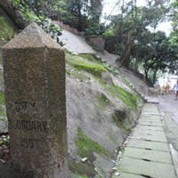
CITY BOUNDARY (Old Peak)
Dublin Core
Title
CITY BOUNDARY (Old Peak)
Description
The Hong Kong government erected several boundary stones in 1903 to mark the limits of the City of Victoria. Measuring 98 cm in height, tapered at the top and with the inscription ‘City Boundary 1903’, this one on Hatton Road is similar to its fellows but still in its original location. As the city’s boundaries were clearly defined by ordinance, these stones were more just physical markers, but are now historical relics.
Creator
Hong Kong Government
Date
1903
Contributor
Hong Kong Government
Rights
No Vandalism and looting
Maintain noise and avoid disturbance to the public.
Do not remove or destruct cultural materials.
Read the information attached to its item to avoid misinterpretation.
Observe the guidelines bounded to each site.
Maintain noise and avoid disturbance to the public.
Do not remove or destruct cultural materials.
Read the information attached to its item to avoid misinterpretation.
Observe the guidelines bounded to each site.
Relation
Tram; Pedder Building; Dr. Sun Yat Sen Museum; Old Central Police Station; Government House; Court of Final Appeal; Victoria Prison; St.John's Cathedral; Former Central Magistracy; Foreign Correspondents Club; Former French Mission Building; Helena May; Cathedral of the Immaculate Conception; Star Ferry; Rawlinson House; Wavell House
Format
N.A.
Identifier
central_cityboundaryoldpeak
Infrastructure (Building and Statue) Item Type Metadata
Opening Hours
Monday-Sunday: 00:00 - 23:59
Nearest MTR Station and Exit
Central Exit D2
Walking distance from nearest MTR
1,400m
Collection
Citation
Hong Kong Government , “CITY BOUNDARY (Old Peak),” The Rajawali Merdeka Digitisation Movement, accessed January 18, 2026, https://learning.hku.hk/ccch9051/group-38/items/show/63.
Embed
Copy the code below into your web page
